


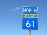
Highway 61
If you really want to know what they mean when they say, “ you’re not in Kansas anymore,” just ride north on I-35 from the Twin Cities toward Duluth. Outside of Duluth atop Thompson Hill, near Spirit Mountain Ski Resort and the port of Duluth, MN, the St. Louis River estuary and the whole expanse of western Lake Superior opens up 500 feet below, as you descend through some pretty nice curves to the lake basin below.
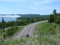
This is just the beginning of the ride northeast up the North Shore Scenic Drive, better known as Highway 61. Yup, that’s the same Highway 61 Bob Dylan sang about in the Sixties. This route hugs the shoreline of the big lake for its entire 150 miles between Duluth and the Canadian border; it’s a scenic byway, and has even been accorded status as an All-American Roadway, the crème-de-la-crème of scenic roads. It's also a segment of the 1300-mile Lake Superior Circle Route (see the story here). On a bike, the trip is best taken in July, August, or early September, for obvious reasons. This far north and this close to a vast body of water, we’d recommend you keep your leathers close by.
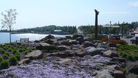
If you do start from Duluth, be sure to spend some time taking in the sights of this hillside city first. Canal Park is the waterfront destination downtown, and you’ll also find hotels, trendy stores, plenty of restaurants and micro-breweries, the Lakewalk, and of course the Aerial Lift Bridge nearby. A lot of bikers make a stop at the Aerostich factory store in west Duluth to check out the amazing assortment of riding gear.
The real ride begins where I-35 ends in east Duluth. It turns onto London Road, a 3-mile ride through a lakefront neighborhood of spendy homes, including the tourable Glensheen mansion. Once you cross the Lester River, you can opt for taking North Shore Drive along the lake, or the quicker expressway 25 miles to the city of Two Harbors. At Two Harbors, head down to the real waterfront downtown, complete with thousand-foot ships loading taconite at the massive ore docks, a railroad museum, and a lighthouse bed and breakfast.
Beyond Two Harbors, heading northeast on Highway 61, you’ll start to see how the rocky north side of Lake Superior differs from the sandy southern shore in Wisconsin and Michigan. Towering basalt cliffs on your left, and shimmering Lake Superior off your throttle hand make this ride special. As you rumble through Silver Creek Cliff and the Lafayette Bluff tunnels you’ll eventually come upon the little hamlet of Castle Danger, and then Gooseberry Falls State Park.
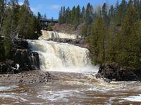
Gooseberry Falls
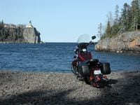
Seven miles beyond Gooseberry is Split Rock Lighthouse. Don’t miss the obligatory stop to see the waterfalls at Gooseberry River, and then be sure to linger at the historic lighthouse. From the top of the lighthouse you can see deep into the clear water below, and way across the lake to Wisconsin and the Apostle Islands 30 miles away. The lighthouse is now a state historic site and you can learn how the keepers and their families lived 100 years ago, when only a boat could get you here. So many motorcyclists stop at the lighthouse that they even offer a Split Rock Lighthouse-Hwy. 61 motorcycle t-shirt to add to your collection.
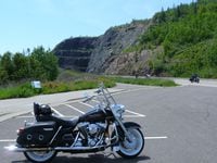
Another stop you won’t want to miss is Palisade Head, about 12 miles up the shore from Split Rock. A quarter-mile paved road will take you to a small parking area atop this 300 foot cliff, which is part of Tettegouche State Park, just one of seven state parks along the shore between Duluth and the border. That means plenty of good camping for those with a tent and a bag to throw down.
The little towns of Beaver Bay, Silver Bay, Schroeder, Tofte, and Lutsen offer plenty of great dining and lodging options, but remember that summer on the North Shore is prime travel time, so plan ahead. It’s best to get a reservation or try to check in early in the day.
Picturesque Grand Marais is the last sizable town south of the Canadian border, and worth a stop for pizza at Sven and Ole’s, or the Lake Superior Trading Post, both on the waterfront.
Grand Marais
About five miles south of the international border is the small Ojibwe community of Grand Portage. Check out the historic fort, the visitor center, and the nearby casino. If you make it this far, you might as well go the last few miles to the border and stop at Ryden’s store. Make sure you pull off at the Mount Josephine overlook along Hwy. 61, so you can view Isle Royale, the Susie Islands, and the Rock of Ages Lighthouse looming atop a sunken reef miles away in the lake.
Continuing up Ontario’s Highway 61, the vistas and the road only get better. The city of Thunder Bay is about 45 miles north of the border and well worth the scenic ride; just remember that Ontario requires helmets and crossing into Canada requires a passport.
There are also plenty of scenic side trips off the North Shore Scenic Drive. The Superior National Forest Scenic Byway takes you on a 60-mile ride through national forest to the Mesabi Iron Range, starting at the town of Silver Bay. The Gunflint Trail Scenic Byway, a dead-end route out of Grand Marais, is a sweet ride into the heart of the Boundary Waters Canoe Area Wilderness.
The North Shore Scenic Drive is the kind of trip that’s worth doing in both directions, as the rugged terrain offers up a fairly level but nicely twisting route, and non-stop vistas to boot. Known tongue-in-cheek as the Scandinavian Rivera, the area’s modern lodges and rustic campgrounds mean you can hot tub it or rough it as you like.
Road Notes
Dress for extremes; you'll be riding along the coast of a major body of water. This far north (Lake Superior’s water temperature averages 39 F), you'd better have your leathers handy.
Motorcycle-specific information on the Lake Superior Circle Tour, with maps, scenic attractions and even an iTunes playlist: RideLakeSuperior.com
Maps and route information on Minnesota’s Byways can be found on: SuperiorByways.com.
/cloudfront-us-east-1.images.arcpublishing.com/octane/IWO5T5PBT5E4HFQ5GK47H5YXR4.jpg)
/cloudfront-us-east-1.images.arcpublishing.com/octane/OQVCJOABCFC5NBEF2KIGRCV3XA.jpg)
/cloudfront-us-east-1.images.arcpublishing.com/octane/F3O2DGLA4ZBDJGNVV6T2IUTWK4.jpg)
/cloudfront-us-east-1.images.arcpublishing.com/octane/ZXYQE3MHLFDSPKNGWL7ER5WJ4U.jpg)
/cloudfront-us-east-1.images.arcpublishing.com/octane/RDF24VM7WVCOBPIR3V3R4KS63U.jpg)
/cloudfront-us-east-1.images.arcpublishing.com/octane/W7RSIBFISNHJLIJESSWTEBTZRQ.jpg)
/cloudfront-us-east-1.images.arcpublishing.com/octane/AERA26ENRNBW3K324YWCPEXYKM.jpg)
/cloudfront-us-east-1.images.arcpublishing.com/octane/YWX3YX7QBBHFXFDMEEEKRG4XJE.jpg)
/cloudfront-us-east-1.images.arcpublishing.com/octane/I7OKI53SZNDOBD2QPXV5VW4AR4.jpg)
/cloudfront-us-east-1.images.arcpublishing.com/octane/IH52EK3ZYZEDRD3HI3QAYOQOQY.jpg)
/cloudfront-us-east-1.images.arcpublishing.com/octane/K2FSAN7OWNAXRJBY32DMVINA44.jpg)
/cloudfront-us-east-1.images.arcpublishing.com/octane/G4XK7JL24FCUTKLZWUFVXOSOGE.jpg)
/cloudfront-us-east-1.images.arcpublishing.com/octane/JJNXVAC27ZCDDCMTHTQZTHO55Y.jpg)


/cloudfront-us-east-1.images.arcpublishing.com/octane/3VSTLPKOHNFTRJTIAAXDPGCPA4.jpg)