Wanna get really high? Go to Hilo.
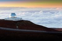
From there, it’s 43 scenic miles to the top of the Mauna Kea volcano on the island of Hawaii. The ride takes you through a wild variety of the island’s ecosystems, from the sea-level, tropical rainforest vibe of Hilo, through ‘Ohi’a forests, up the side of Mauna Kea through ranch land and then to the top, where you’ll find precious little oxygen. There’s not much growing up there, but on a clear day, you’ll have a sprawling view of Maui and the rest of the neighboring islands.
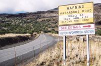
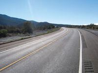
The actual road to the Mauna Kea summit, officially called John A. Burns way (though it’s usually just “the Mauna Kea summit road”), splits north from Route 200—the narrow and sometimes treacherous Saddle Road. The Saddle Road winds between the Mauna Loa and Mauna Kea volcanoes at an elevation of 6,600 feet, and parts of it are narrow and rough, making for some dicey riding conditions. What’s more, this place gets some seriously dense fog—a real concern if you happen to meet one of the invisible cows mentioned in the signs along the road!
The Manua Kea Access Road itself is about 15 miles long and paved up to the Onizuka Center for International Astronomy Visitor Station, sitting at about 9,200 feet. After that, it’s a steep dirt grade for five miles—so you’re better off calling it a day at the visitor center unless you’re on a BMW R1200GS, even if the last few miles to the summit are paved. the road tops out at 13,780 feet, becoming the third highest auto road in the US, and the highest in Hawaii.
Ending the ride at the visitor center makes for a great day trip, but you’re still going from sea level to 9,000 feet in a short time, so stop often to acclimate, use common sense and pack a layer. Check the forecast, too: it can often be cold and windy at the top.

/cloudfront-us-east-1.images.arcpublishing.com/octane/OQVCJOABCFC5NBEF2KIGRCV3XA.jpg)
/cloudfront-us-east-1.images.arcpublishing.com/octane/F3O2DGLA4ZBDJGNVV6T2IUTWK4.jpg)
/cloudfront-us-east-1.images.arcpublishing.com/octane/ZXYQE3MHLFDSPKNGWL7ER5WJ4U.jpg)
/cloudfront-us-east-1.images.arcpublishing.com/octane/RDF24VM7WVCOBPIR3V3R4KS63U.jpg)
/cloudfront-us-east-1.images.arcpublishing.com/octane/W7RSIBFISNHJLIJESSWTEBTZRQ.jpg)
/cloudfront-us-east-1.images.arcpublishing.com/octane/AERA26ENRNBW3K324YWCPEXYKM.jpg)
/cloudfront-us-east-1.images.arcpublishing.com/octane/YWX3YX7QBBHFXFDMEEEKRG4XJE.jpg)
/cloudfront-us-east-1.images.arcpublishing.com/octane/I7OKI53SZNDOBD2QPXV5VW4AR4.jpg)
/cloudfront-us-east-1.images.arcpublishing.com/octane/IH52EK3ZYZEDRD3HI3QAYOQOQY.jpg)
/cloudfront-us-east-1.images.arcpublishing.com/octane/K2FSAN7OWNAXRJBY32DMVINA44.jpg)
/cloudfront-us-east-1.images.arcpublishing.com/octane/G4XK7JL24FCUTKLZWUFVXOSOGE.jpg)
/cloudfront-us-east-1.images.arcpublishing.com/octane/JJNXVAC27ZCDDCMTHTQZTHO55Y.jpg)

/cloudfront-us-east-1.images.arcpublishing.com/octane/3VSTLPKOHNFTRJTIAAXDPGCPA4.jpg)
